SearchUser loginOffice of CitizenRest in Peace,
Who's new
Subscribe |
What types of structures stood up to the Haiti quake?Submitted by Jeff Buster on Sat, 01/23/2010 - 08:32.
This before and after image from BBC News suggests that with regard to the forces of the recent earthquake, concrete domes have a structural advantage over flat parallel wall/box shape concrete construction.
In the images I have seen, the damage from the earthquake was concentrated in the upper corners of masonry buildings. Wall sections were not damaged near the ground, but rather at the wall/roof connections.
Where rigid, heavy, water resistant masonry construction has many advantages with regard to hurricanes and moisture in the Caribbean, but catastrophic disadvantages from seismic activity as seen in this earthquake, defining a structural shape for concrete buildings which can withstand earthquakes is very important.
Dome shaped concrete buildings could be one answer.
Hopefully structural engineers and others are using helicopters to record images of the failed and still standing civil and residential structures across Haiti in order to develop a thorough forensic data base to allow as great an improvement as possible in the seismic stability of the built environment around the world.
Personally, I think developing such a data base would be a very satisfying task.
( categories: )
|
Support Civic Journalism Recent commentsPopular contentToday's:
All time:Last viewed:
|

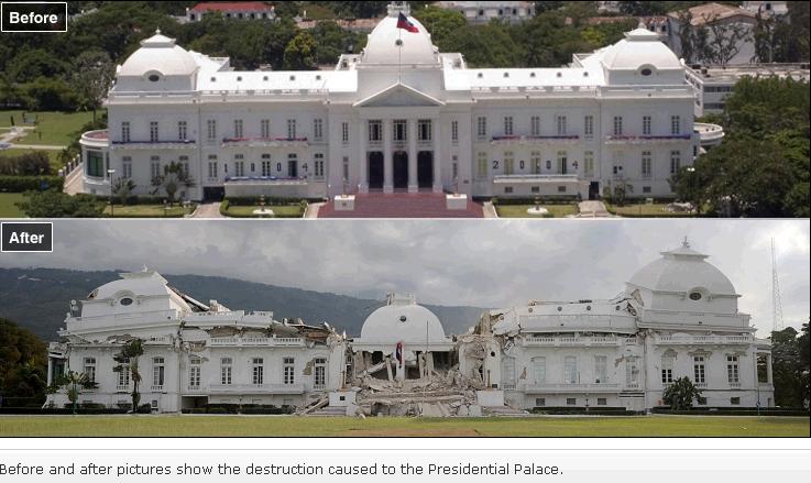 The 3 concrete domes on the Presidential Palace in Haiti not only survived the recent earthquake intact, they also appear to have survived their fall from their positions as roofs over the second floor of the Palace to their final resting positions on the rubble of the first floor.
Rochester Institute of Technology maps Haiti quake aftermath
RIT maps
Thanks for sharing this, jbuster. Not only does it help regarding the type of structures that held up, the mapping and thermal imaging can tell workers where the storage of liquids are at so that they can safely evacuate.
RIT is an amazing institution. I attended a graduation there this past June of a family member who graduated from Cleveland Public Schools. This institution is on the cutting edge edge of technology, and this Science Daily article shows that.
I wonder how this mapping can be used on disasters that do not involve brick and mortar, such as a major oil spill.