SearchUser loginOffice of CitizenRest in Peace,
Who's new
Subscribe |
I Think Ed Hauser Would Like This - A Proposed Path To Wendy ParkSubmitted by Charles Frost on Sat, 01/10/2009 - 21:09.
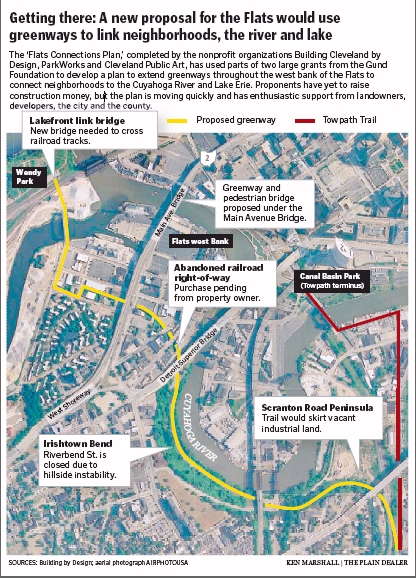
Graphic From: http://blog.cleveland.com/pdgraphics/2009/01/10EGFLATS.pdf (1.8 Megabite PDF File) 'Flats Connections Plan' would add parks, trails on west bank sitePosted by dsims January 09, 2009 22:50PMThe gray industrial landscape and parking lots on the west bank of the Flats, now edged with housing and nightclubs, could soon be crisscrossed with parks, trails and green spaces. The new "Flats Connections Plan," completed by the nonprofit organizations ParkWorks, Cleveland Public Art and Building Cleveland by Design, shows how an abandoned railway and the vacant strip under the Main Avenue Bridge could become playgrounds, bikeways and artificial wetlands. "We think there's a huge opportunity to realize this in the short term," said Ann Zoller, director of ParkWorks. She said major elements of the proposal could be achieved within several years, despite the recent economic downturn and the sudden halt of major projects, including the $522 million Flats East Bank development. "We think [the plan] is dynamic and wonderful and creates just the right kind of connections," said Jon Ratner, sustainability director for Forest City Enterprises, which has vacant industrial property along the proposed route on Scranton Road Peninsula. "I can't think of enough superlatives to describe the kind of park they're planning," he said. A diagram of the plan shows how the rail path and the land under the bridge would intersect like a giant green cross in an area where industrial properties and vacant lots are slowly being converted to housing and offices. The paths would link the Tremont and Ohio City neighborhoods to the Cuyahoga River and Whiskey Island on the Lake Erie waterfront, via the Willow Street Bridge. Two pedestrian bridges -- one over the river and another over rail tracks on the south side of Whiskey Island -- would complete the connections. The backers used part of $740,000 in grants from the George Gund Foundation for the plan, which has been under discussion since 2006. The proposal is gaining strong support from landowners, developers, the city of Cleveland and Cuyahoga County. Zoller and other supporters said the concept is relatively feasible because few landowners are involved, and because major developers in the Flats like the idea. Willett Moss of CMG, the San Francisco landscape firm that authored the plan, said the goal was "to see what you can do for very little money to give the site definition and identity." Among the ideas proposed by CMG is to turn the land under the Main Avenue Bridge into play areas, a trail and wetlands that would filter runoff from the traffic lanes high overhead because the water enters the Cuyahoga River. County Engineer Robert Klaiber said Friday that the county, which owns the land under the bridge, supports the idea. The trails proposed by ParkWorks would connect with a much larger regional hike-and-bike trail under development along the old route of the Ohio & Erie Canal towpath from Cleveland 110 miles south to New Philadelphia in Tuscarawas County. The final northern sections of the towpath trail could reach Canal Basin -- the original starting point of the canal -- in four or five years, Tim Donovan, director of the nonprofit Ohio Canal Corridor, said Friday. Zoller and her partners haven't completed cost estimates for their Flats proposal or raised construction money. But they're moving quickly to acquire the major pieces of property. In addition to the area below the Main Avenue Bridge, the other big chunk is the abandoned rail bed of the Ohio & Mahoning Valley Railroad, finished in 1856. The rail path, which includes massive stone retaining walls and bridges, slices 1.2 miles from the base of Scranton Road Peninsula north to River Road along the old channel of the Cuyahoga River. The route is owned by Cleveland investor and former Cuyahoga Community College professor Earl Walker, who said through a spokesman that he supports the plan and wants to help close a deal. "He's very excited about the transaction, not only for himself but for the city of Cleveland," said Walker's broker, Keith Brown, president of Progressive Urban Real Estate. "Everybody's on the same page and has the same goal in mind." William Carroll, director of the Ohio branch of the nonprofit Trust for Public Land, is leading negotiations to acquire the railway path from Walker in an arrangement that could include a $1.3 million grant from the state's Clean Ohio Fund. "We think we can get site control . . . within the next year," Carroll said. He said he hoped some construction money might be available under the economic stimulus proposal being discussed by President-elect Barack Obama. Carroll said the Flats proposal is similar to efforts carried out by the Civilian Conservation Corps during the Depression. Ratner, of Forest City, said his company might allow a portion of the fallow industrial land next to the proposed trail route to be used at least on a temporary basis as a park. Along the next section to the north, the rail path skirts Irishtown Bend, the site of a 19th-century shantytown, before passing under the massive twin stone arches of a bridge below Detroit Avenue. The span is the oldest extant bridge in Cleveland, according to the federal Historic American Engineering Record. Zoller and other advocates said the Irishtown Bend section of the trail couldn't be built until after the Army Corps of Engineers completes a study in February on how to stabilize the riverbank, which is slowly sliding toward the river. Cleveland Planning Director Robert Brown said that while the city supports the plan, it also recognizes that industrial activity in the district -- including the Cargill salt mine on Whiskey Island -- is firmly rooted in the Flats. Zoller said, however, "there's a recognition that the Flats is shifting, that change is coming, and there's a need to work together for a balanced vision. The industrial nature of the Flats gives it its grit and character. We don't see this as either-or." From: http://blog.cleveland.com/architecture/2009/01/flats_connections_plan_would_a.html
( categories: )
|
Support Civic Journalism Recent commentsPopular contentToday's:
All time:Last viewed:
|

Go Parkworks the East Bank of the Flats first
I think Ed would have wanted to see a way to cross to Wendy Park from the Flats... right now it is obstructed by rail lines and fences... and I think Cargill has property blocking access... but I'm concerned that everything else planned here is redundant with existing public access - very interesting low traffic roads - and so a waste of time and money to double-up... especially if it benefits Forest City or any other current major real estate developers or property owners in the Flats, Tremont or Ohio City in any way... they have blighted these areas and they should be sued for demolition of Cleveland with contempt.
I can think of 1,000 urgent needs of any funds that any of these organizations or people may be able to pull together, whether Parkworks or local architects.
Before I will support any plans of the current administrations and their failed leaders I will want to follow every penny of the money - this plan sounds like a big waste of public and private funds and resources to benefit failed old economy cheaters - I do not support that.
Go see what they just did to the East Bank of the Flats... go Parkworks that...
Ed was committed to the Huletts so donations and volunteer community efforts in Ed's interests may be made for that.
Disrupt IT
I dont mean to be rude...
... but I kinda LIKe the fact that most people dont know how to get to Wendy Park... Its like when I lived in the Keys and we "locals" had beautiful little stretches of sandy beach (a rarity in the coral reef/mangrove laden Keys) that were at the end of long windy paths fit for one vehicle at a time....
Better human access... sue landowners
It is a shame Edgewater Park and Whiskey Island don't have better human access - it would be nice to have a low cost way to get across the tracks to reach the park from the Flats - that done, money should go toward more important greening and infrastructure needs than this developer-driven crap.
Sue the developers to make them clean up, detoxify, and bring up to code and environmental standards their own property, at their expense, or force them to turn it over to the public and then we can decide how we invest in our property... not that of Forest City and some "Cleveland investor".
Sue them!
Disrupt IT
Tale of Two Cities
I GET IT... helping Forest City...that's what WE do every day...here in the tale of two cities...but who is Earl Walker??? Is this the guy?
If so, the Case article notes that he WAS a resident of University Circle for many years...
It saddened me today to see that artist* Hector Vega now enjoys the best of both worlds by living in Kirtland on four urban-subsidized acres and deriving his income (must be some income?!) as a construction manager for CMHA. Well Hector...your best of both worlds comes at a HUMAN cost...and those of us living in the city pay for it....by subsidizing the Opportunity Corridors that take you from your residential oasis to your paycheck in the CITY.
*change the names here to Sheryl Hoffman/Abe Bruckman--same story...add Holly Harlan, now comfortably relocated to Geauga County...who's next? The sustainable CITY is only good for some people?? The right people??
low cost green infrastructure
I'm not quite sure while most comments regarding this story make it seem like another ciyt/county/developer boondoggle.
Clearly stated in the story is that this is an inexpensive plan. "Willett Moss of CMG, the San Francisco landscape firm that authored the plan, said the goal was "to see what you can do for very little money to give the site definition and identity."
Re-using old railbeds for bicycle/pedestrian paths and creating constructed wetlands to temporarily store and filter rainwater are perfect applications of low-tech green infrastructure for this particular site. Furthermore, such projects seem like great applications to provide 'green-collar' job training to people that are re-entering society. Note the comment by William Carroll, Director of the OH Office of the Trust for Public Land: "the Flats proposal is similar to efforts carried out by the Civilian Conservation Corps during the Depression." Additionally, this project may be eligible for Obama's much discussed stimulus money. Isn't the rehabilitation of one of CLV's most unique assets (the Flats) for use by human beings, a far better use of said money than building/repaving more roads & bridges, which are exclusively for cars?
This project really seems like a win for all who want a more sustainable and better connected city. I would be a full supporter if this project could be used as green collar job training for those entering or re-entering the workforce. These types of projects really do not necessitate earth moving machinery, but rather many hands with shovels and determination.
HAND BUILT BIKEWAY BEST
John,
I have walked the entire suggested route and I wholeheartedly agree with you. I agree both that this path is a positive development for Cleveland and the public, and that its construction should be accomplished entirely by hand labor – not excavators and dozers.
A year ago when I visited Whiskey Island with Ed Hauser, I asked him about his thoughts of how new access for pedestrian and bike traffic should be designed to reach Whiskey Island.
Ed had two thoughts:
Ed suggested that the design for the first and cheapest access was a pedestrian/bike walkway/ramp/bridge over the railroad tracks right on the west side of the Cuyahoga where the brick lift-bridge controller’s house is now (this is the same location as shown by the top end of the yellow line on the “flats connection plan” posted by Bill MacDermott at the top of this report)
The second design thought Ed had – because he wanted the Canal Path Trail to eventually come all the way to the Lake on the East side of the Cuyahoga – was that a new pedestrian/bike bridge could be engineered to be an “outrigger” bridge deck attached to the existing RR lift-bridge. With access to both sides of the Cuyahoga a circular trail could be developed - and this circle route would be much more interesting and attractive for an outing and would attract more users.
Combining people and bikes with active rail road traffic is a real challenge – but it is being done more and more around the country with keen attention to safety separation barriers (fences) between the pedestrian ways and the railroad ROW. Here is an article about the dual use of an active rail road right of way in Massachusetts. Because the existing lift-bridge is humanly controlled 247, it seems to me that a design to combine a new pedestrian connection in Siamese with the lift-bridge is entirely practical.
One concern I have relates to the failing soil conditions along the bank of the Cuyahoga at Irish Town Bend. Besides the fact that the primary sewer collector for the entire west side of Cleveland is at jeopardy because of the soil instability at Irish Town (lots of talk about the inner belt bridge being an accident waiting to happen – this sewer is even a more exigent circumstance), I wonder what the “fair market value” of the land in this collapsing area is.
I would suggest that the wildly unstable (go look at the cracked and subsided street) land is a liability to the owner – not an asset. So if this means that the RR ROW in this area belongs to Earl Walker, then William Carrol needs to get the Bend stretch for not more than a dollar (sorry Mr. Walker – but the rest of your RR ROW probably has value)
Lastly, in agreement with Norm’s comments, I can’t see why there is any need to quote Jon Ratner. Is Forest City selling any land? I don’t think so. It appears Mr. Ratner was quoted merely for the sake of appeasement, and that needs to stop in NEO.
HAND BUILT! BIKE ON!
part of $740,000 in grants is already too much
It sounds like The Gund Foundation funded this plan and they are part of funding Fund For Our Economic Future, largely controlled by the Cleveland Foundation and McKinsey consultants. Collectively, collusively, with large industrial Greater Cleveland Partners and largely uncreative, underinvesting, blighting land owners and developers like Marous Brothers/Vintage/Battery Park, Forest City/Ratner/Miller, Jacobs, Developers Diversified/Wolstein... with elected officials groomed if nor selected by the Foundations and their Greater Cleveland Partners, and the Cleveland Plain Dealer... all with the permission of Jones Day and Squire Sanders.
And you want Obama money to go to any of that. Please.
They already spent all the foundation money they should on this (with an out of town planner) and the foundations are going to be way short for the next many years, so folks may not want to plan on working in the non-profit foundation-funded world around here... many red slips and canceled projects, bankruptcies and other casualties ahead.
So what is the economic model for this project paying for itself - you'd better get very creative and cost benefit oriented.
My proposal is we go over to Whiskey Island with wire cutters and we open the public land up to the public, who may walk across the tracks (after looking both ways). If the railroad wants to do some work on the crossing, they should at their expense. There are many street level rail auto crossings all over Lakewood so don't tell me we can't do it there.
At that point, people may get from Whiskey Island to anywhere in the Flats or world they like, without enriching a bunch of Greater Cleveland Partners, and denying poor people costly services and real life changing opportunities.
Public cost... $0
That's panning for survival rather than philanthropy for the rich.
Disrupt IT
ParkWorks, Cleveland Public Art and Building Cleveland by Design
In times when all money will be tight and future participation in the new economy will be selective, those who have shown the right type of good character and outcomes in the past, and are well aligned for the future, may survive.
I think my primary question about all this is what are the value of ParkWorks, Cleveland Public Art and Building Cleveland by Design and are they positioned for the future, themselves. What do they cost, how well do they perform, and what are they worth to you...especially as taxpayers always get stuck paying the tab.
Disrupt IT
Building Cleveland by Design works for Wolstein
The weirdest of the three - Building Cleveland by Design - a non-profit spin-off of ParkWorks with one employee who is touted to be our new big sustainability planner but seems far from qualified or experienced to fit any such shoes... they are one of the shell non-profits in town which took funding and focus away from good folks like Ed Hauser and their good efforts.
Here is what they (actually, one 33 year old kinda-planner) claim about his role in planning the Flats:
Here's their history, from their astoundingly overblown and misleading website, highlight below, which says they were funded for two years (I'd like an accounting of every penny of that) to help Wolstein bulldoze the East Bank of the Flats and make citizens think that is smart and green.
Now that the project is a bust - a disaster area - this ne man wrecking crew should shut down and this "planner" and all his partners should be ashamed for helping Wolstein demolish an important part of our real history.
Disrupt IT