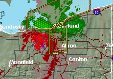
Right now it looks like Cleveland area is in the lull between the front and rear cyclonic edges. Image from NWService
Read about how radar images of weather fronts are developed on the National Weather Service web site [1]. The basics are as follows (from NWS):
What are the different types of radar images?
There are six different types of images currently available for the RIDGE radar display: Base Reflectivity, Composite Reflectivity, Base Velocity, Storm Relative Motion, One-hour Precipitation and Storm Total Precipitation.
- Base Reflectivity
- This is a display of echo intensity (reflectivity) measured in dBZ (decibels of Z, where Z represents the energy reflected back to the radar). "Reflectivity" is the amount of transmitted power returned to the radar receiver. Base Reflectivity images are available at several different elevation angles (tilts) of the antenna and are used to detect precipitation, evaluate storm structure, locate atmospheric boundaries and determine hail potential.
The base reflectivity image is from the lowest "tilt" angle (0.5°). This means the radar's antenna is tilted 0.5° above the horizon. Learn more about Base Reflectivity. [2]
- Composite Reflectivity
- This display is of maximum echo intensity (reflectivity) from any elevation angle at every range from the radar. This product is used to reveal the highest reflectivity in all echoes. When compared with Base Reflectivity, the Composite Reflectivity can reveal important storm structure features and intensity trends of storms. Learn more about composite reflectivity. [3]
- Base Velocity
- This display of radial velocity [4] represents the overall wind field. Green colors indicate wind moving toward the radar with red colors indicating wind moving away from the radar. The maximum range of this product is 124 nm (about 143 miles) from the radar location. Learn more about Base Velocity images. [5]
| Attachment | Size |
|---|---|
| Radar_cleveland_storm.jpg [6] | 30.9 KB |